Live project
We are working with Falkirk Council and Inner Forth Futures to make Rannoch Park more climate resilient and welcoming for the local community.
Introduction
Rannoch Park in Grangemouth was identified as a suitable greenspace for improvement works that will support the delivery of the Climate FORTH (Furthering Our Resilience Through Heritage) project by Inner Forth Futures (IFF).
We are delivering a series of interventions at Rannoch Park, which focus on reducing the impacts of heavy rainfall and supporting climate adaptation and resilience.
Works at the park began in early December 2024 and will be completed by autumn 2025.

About the interventions
This project will deliver multiple outcomes at Rannoch Park across these key areas:

New shallow detention basins and swales will help store and manage excess surface water. New woodland and naturalised grass planting will help lock water in the soil.

New native woodland planting will intercept noise, create shade and provide habitat and forage for wildlife.

Creation of shallow basins and a swale, as well as new woodland areas, will create habitat for wildlife and boost biodiversity.
Improvements include new paths and leisure areas to develop quality greenspace for local residents and visitors.
The works taking place at the park will focus on reducing the impacts of heavy rainfall and supporting climate adaptation and resilience. A scoping exercise for this project was conducted on behalf of Inner Forth Futures.
We spoke to local residents and users of Rannoch Park to gather feedback on these proposals, which we then incorporated into our delivery plan. The new improvements include:
The finalised project design can be seen to the left.
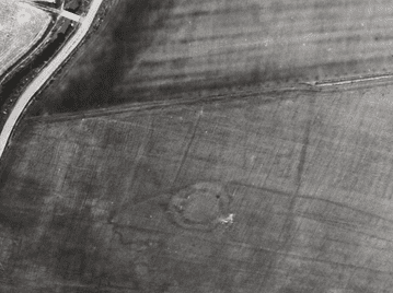
Through the development of the park, a record of a scheduled ancient monument was discovered hidden under the grass. The underground structure is the remains of a homestead site and likely dates from the Iron Age (700BC – 500 AD).
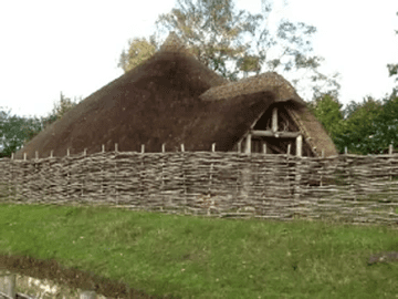
The homestead probably comprised a house surrounded by an enclosure for protection, and would have been situated deliberately for water access from Grange Burn, providing water for the people and livestock living there. It may have looked something like the top image to the right. The surviving underground remains include circular ditches, which can be seen on the below image to the right, and indicate the size and form of the homestead, which would have been a key part of the settlement in the area.
This type of structure is called a Bowhouse, which provides some context to placenames in the area around Rannoch Park.

